
Where Signature Regal sits
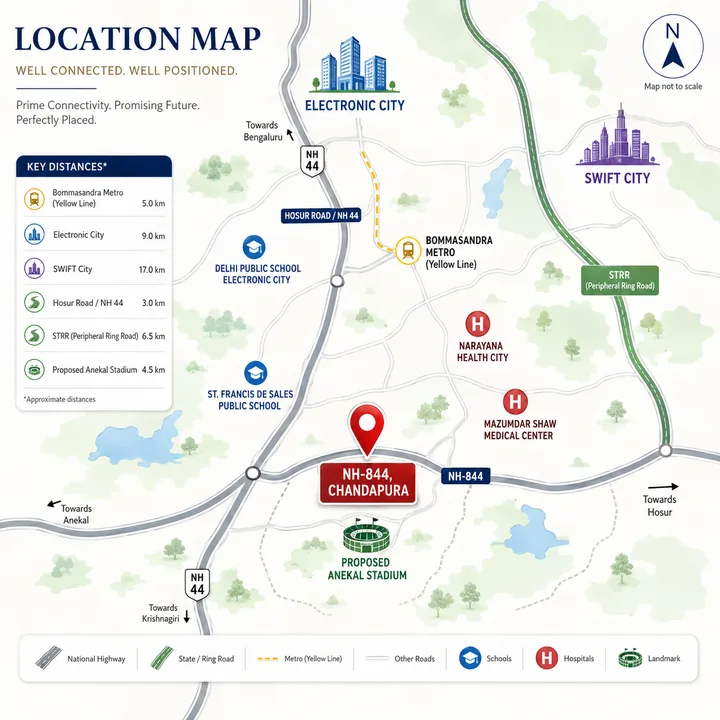
Signature Regal sits in Marasuru Agrahara village, Anekal taluk, south of Hosur Road in the triangle formed by Chandapura, Attibele and Anekal town. NH-844 - the national highway being built from Neraluru through Hosur towards Dharmapuri - runs along its southern boundary. It is a quieter, greener setting than the Hosur Road frontage, with the Bommasandra, Electronic City and Hosur employment belts all within a practical drive. SNN Electronic City is useful for the same-city location lens because the real test is weekday travel, school runs, healthcare access, and how the approach road feels at peak hours.
| Address | Sy No 11/1 – 11/6 and 12/2A – 12/2C, Marasuru Agrahara, and Sy No 225/1 and 225/3, Madiwala Village, Kasaba Hobli, Anekal Taluk, Bengaluru 562106 |
| Micro-market | Chandapura – Anekal belt, south of Hosur Road |
| City | Bengaluru, Karnataka |
| Frontage | NH-844 along the southern boundary |
| Hosur Road (NH-44) | 6 – 7.5 km by road, at Chandapura or Attibele |
| Nearest metro | Bommasandra (Yellow Line terminus), 9 – 9.5 km by road |
View the registered site pin on Google Maps. The map alongside is illustrative and not to scale; the distances on this page are measured by road from the registered site.
Road connectivity and the Yellow Line metro
Hosur Road (NH-44) is the primary arterial, reached at Chandapura or Attibele about 6 to 7.5 km by road from the site; it connects north to the Outer Ring Road at Silk Board, 22 to 23 km away, and south to Hosur in Tamil Nadu. The Electronic City Elevated Expressway, a tolled flyover, lets Hosur Road traffic bypass the surface congestion of the IT cluster. The connectivity story stepped up materially in 2025: the Namma Metro Yellow Line (RV Road to Bommasandra) became operational in August 2025 - 16 stations across about 19 km, fully elevated, interchanging the Green Line at RV Road - with its Bommasandra terminus 9 to 9.5 km by road from the site, a short drive or ride rather than a walk. NH-844, along the site's southern boundary, is still under construction in stretches; as it opens it adds a second route east towards Hosur.
Employment access
The location sits at the southern edge of one of Bengaluru's most established employment catchments, with Tamil Nadu's Hosur industrial belt on the other side.
| Employment hub | Distance by road |
|---|---|
| Narayana Health City, Bommasandra | 7 – 8 km |
| Bommasandra Industrial Area | 8 – 9 km |
| SIPCOT industrial area, Hosur (Tamil Nadu) | About 10 km |
| Electronic City Phase 2 | 13.5 – 14.5 km |
| Electronic City Phase 1 (Infosys, Wipro) | 14 – 15 km |
Free-flowing, these are 10-to-20-minute drives. The honest caveat is that peak-hour traffic on Hosur Road is real - budget 40 minutes or more for Electronic City at rush hour - so the practical commute depends on the specific employer location and travel window, and a rush-hour site visit is the best way to judge it.
Schools, healthcare and retail
Day-to-day services sit along Hosur Road rather than at the gate. Healthcare is anchored by Narayana Health City and the Mazumdar Shaw Medical Center at Bommasandra, 7 to 8 km by road. International schooling includes Ebenezer International School (about 12 km), Indus International School on the Sarjapur - Attibele road (13 to 15 km) and Treamis World School (14 to 15 km). Everyday shopping is in the Chandapura and Attibele town centres, 6 to 7.5 km away, with Decathlon on Hosur Road at Bommasandra 9 to 10 km.
Area-level growth catalysts
Two taluk-level catalysts are worth understanding accurately rather than through the marketing lens. SWIFT City, the 1,000-acre KIADB tech and startup park unveiled in December 2024, is located in Sarjapur Hobli of the same Anekal taluk - a regional growth driver, not a neighbour. The Anekal cricket stadium, an 80,000-seat venue cleared by the Karnataka Cabinet in October 2025 and slated to be India's second-largest, is likewise a taluk-level catalyst whose construction is expected to lift the broader Anekal market over the next three years. Both matter for the area's trajectory; neither is adjacent to the site. The Satellite Town Ring Road, an orbital under development through the taluk, adds to the longer-term connectivity story - Signature Regal's own building plan is sanctioned by the Satellite Town Ring Road Planning Authority.
| Catalyst | Location | Status |
|---|---|---|
| SWIFT City (KIADB) | Sarjapur Hobli, Anekal taluk | Land acquisition in progress |
| Anekal cricket stadium | Anekal taluk | Cleared Oct 2025; phase 1 tendered |
| Yellow Line metro | Bommasandra terminus, 9 – 9.5 km by road | Operational (Aug 2025) |
| NH-844 | Along the site's southern boundary | Under construction in stretches |
| Satellite Town Ring Road | Anekal / outer ring | Under development |
These catalysts are shared by every project in the taluk; Signature Regal's differentiation is the product on its site - the low density and the larger homes - rather than the location. The reviews page works through that comparison.
Schools near Signature Regal
The south-east corridor has matured around the Electronic City and Sarjapur workforce, and its international schools are within a daily drive of the site. Ebenezer International School is about 12 km by road, Indus International School on the Sarjapur - Attibele road 13 to 15 km, and Treamis World School 14 to 15 km; the Chandapura and Attibele town centres add CBSE and state-board options closer in. For a family, the honest read is that the school run is a drive of 25 minutes or more rather than a walk, so it is worth timing the route to your shortlisted school at the morning peak.
| School | Distance by road |
|---|---|
| Ebenezer International School | About 12 km |
| Indus International School, Sarjapur - Attibele Road | 13 – 15 km |
| Treamis World School | 14 – 15 km |
Healthcare and retail
On healthcare, the belt is anchored by Narayana Health City and the Mazumdar Shaw Medical Center at Bommasandra, a major multi-speciality and cardiac campus 7 to 8 km by road, with clinics and nursing homes in the Chandapura and Attibele town centres for everyday needs. On retail, those two town centres, 6 to 7.5 km away, cover daily shopping, with Decathlon on Hosur Road at Bommasandra 9 to 10 km and the larger malls of Electronic City and beyond a longer drive. The honest read is that healthcare is a strong suit, while everyday convenience means a short drive rather than a walk - typical of a site on the green edge of the corridor.
How the location compares in the micro-market
Signature Regal sits further south-east than most projects marketed under the Electronic City name, on the Anekal side of Hosur Road. That costs some distance to the IT cluster and buys a quieter, lower-density setting closer to the Attibele and Hosur industrial belts. What separates the project is the product on its specific site - six homes on a typical floor, the larger unit sizes and 991 covered car parks - and the developer's delivery record in the Chandapura sub-market. A buyer comparing options on the corridor should treat the location as broadly shared and focus the comparison on the per-usable-foot price, the carpet area, the amenity set, and each developer's track record, as the reviews page sets out.
A practical note on judging the location for yourself: the single most useful thing a serious buyer can do is visit the site at Marasuru at a weekday rush hour, and drive from there to their actual office. Road distances of 6 to 7 km to Hosur Road and 14 to 15 km to Electronic City are fixed, but the lived commute depends heavily on the time of day, the direction of travel, and whether the route uses the elevated expressway. The operational Yellow Line metro changes that calculus for anyone whose workplace is near a station, since a metro leg sidesteps the road entirely - so it is worth checking how far the Bommasandra terminus is from both the site and your destination. Grounding the location decision in a real journey, rather than a brochure map, is the discipline that separates a confident purchase from a hopeful one.
Signature Regal Location FAQs
Where exactly is Signature Regal located?
At Marasuru Agrahara in Anekal taluk, Bengaluru 562106, on a site bounded to the south by NH-844. Hosur Road is about 6 to 7 km by road at Chandapura or Attibele, and Electronic City Phase 1 is about 14 to 15 km.
How far is the nearest metro station?
The nearest metro station is Bommasandra, the southern terminus of the Namma Metro Yellow Line, operational since August 2025 and about 9 to 9.5 km by road from the site. The line runs from RV Road to Bommasandra through the Electronic City and Bommasandra employment zones.
How is the commute to Electronic City in practice?
The Phase 1 and Phase 2 clusters are about 13.5 to 15 km by road via Chandapura and Hosur Road, with the Electronic City Elevated Expressway bypassing the worst of the congestion further north. Allow 40 minutes or more at peak; the practical commute depends on the employer location and travel window, and a rush-hour site visit shows this best.
What is SWIFT City and how close is it?
SWIFT City is a 1,000-acre KIADB tech and startup park unveiled in December 2024, in Sarjapur Hobli of Anekal taluk. It is a regional growth driver in the same taluk - a structural catalyst for the south-east corridor rather than an adjacent landmark.
Is the Anekal cricket stadium near the project?
The 80,000-seat Anekal cricket stadium, cleared by the Karnataka Cabinet in October 2025 and set to be India's second-largest, is being built in Anekal taluk. Like SWIFT City, it is a taluk-level catalyst expected to lift the surrounding market, rather than a fence-line neighbour.